SmartGIS
The special geographical information system (GIS)
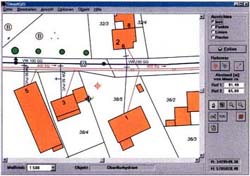
SmartGIS - the easy to handle data administration
SmartGIS is the base for the efficient and economical management of supply enterprises. With this system the necessary data for planning and maintenance of the mains are available central as well as in the field.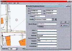
- Simplest operation (no CAD knowledge necessary)
- Integration of already existing data (plans, tables)
- The different supply mains (water, gas, waste water) are stored in different layers and can be displayed seperately or all together.
- Data transfer is possible with many other systems.
- Object-oriented data base - objekts, drawings, lines etc. can be received digitally or by hand


